
2023 isn’t even six months old yet, but the news cycle has been awash with stories of disasters, both natural and man-made. As the rate of these disasters increases due to global warming and decreased safety regulations respectively, what can the governments and businesses of the world do as we head into the second half of the year and beyond?
One area of technology that shows promise is in drones, specifically enterprise drones from DJI. Regular readers would have seen our first article on this topic which you can catch up on here to see how the Mavic 3 is the entry point for everyone to get into the world of DJI’s enterprise solutions.
The Mavic 3 comes in two flavours: the Mavic 3E and the Mavic 3T. Both are similar platforms – again see our previous article for more on these versatile but compact platforms – but they differ greatly when it comes to optics.
The DJI Mavic 3E comes equipped with a 20MP, 4/3 CMOS sensor while the DJI Mavic 3T comes with a 48MP, 1/2-inch CMOS sensor.

The real difference is the fact that the 3T, as you may have guessed by the name, is a drone with a built-in thermal camera. The camera has a resolution of 640 X 512 that supports several features to make it as versatile as possible. One feature is the side-by-side continuous zoom which allows drone operators to compare what an image looks like to the naked eye, and what it looks like through thermal vision.
In the middle of a tense situation this can make all the difference as a situation that looks normal on the surface can be dangerous in a way only the drone can see. The door knob that’s too hot to touch, the fire that’s more dangerous than it seems, the people hidden by rubble that may have been missed… all situations where a thermal imaging camera can’t be beat, especially when mounted on the small and manoeuvrable body of a DJI Mavic 3T.
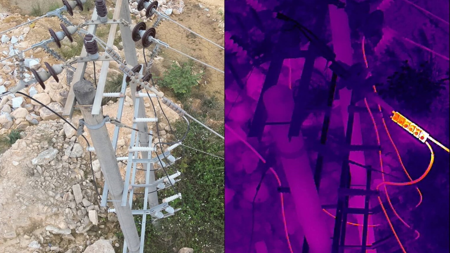
While tackling disasters as they happen, preventing them is usually more prudent. You can see an example of this in our header image above, showing a powerline with a fault that looks normal on the surface but, thanks to the side-by-side, we can see where the fault is by the high temperature. A shot of a power line high in the air is another environment where drones shine, allowing for eyes in the sky where other options don’t make sense.
Where options like helicopters are too large, expensive and dangerous drones are there. When land options such as booms and scissor-lifts are impossible due to terrain, drones are there. For those of us who live in cities where power lines mainly cross streets and grasslands, this type of intervention may seem unneeded, but when power lines are crossing over outback terrain and mountainous areas, drones are once again there.
Other features of the thermal imagery that DJI has engineered into the Mavic 3T include point and area temperature measurements, colour palettes, isotherms and the DJI Thermal Analysis Tool 3.0. Software like this again falls into the realm of disaster prevention, as captured footage can be processed later for a more thorough inspection.
If you, your business or your government is interested in DJI enterprise drones to fight disasters or prevent them, do not hesitate to contact the South African partner companies who will work with you to create the perfect drone platform to achieve your needs:
- Hennie’s Drone Repair and Training orders[at]hdrt[dot]co[dot]za,
- TeleEye jacques[at]GoUAV[dot]co[dot]za,
- Africa Drone Kings vice[at]africadronekings[dot]co[dot]za.

